Greece Property for Sale - Real Estate In Greece Buy & Sell |
| Karpathos Property & Houses For Sale - Real Estate In Greece 0 Property(s) Found - Page 1 of 0 - Updated: 4/19/2024 |
|
FEATURED PROPERTIES: Ikaria - Armenistis New Maisonettes Price: €209,000 - 125 m2 Bedrooms: 3 Baths: 2  |
KARPATHOS
Karpathos Characteristics
Island Features
Karpathos has sent many of its sons and daughters to far shores in order to survive. They retain a strong affection for their native island, however. Survive they did, sending back more money to this island than any other in Greece. Most went to the United States, to New Jersey in particular. Many have retired back on the island. Others come back as often as possible and some even ship their bodies back here for burial. The island has a tradition of lyrical poetry. Impromptu singing contests feature a style of 15-syllable couplets. Two Austrians published a book (with cassette) in 1992 that included many island songs. The book was Die Volksmusik der Insel Karpathos. Karpathos Town or Pigadia
Pigadia is Karpathos' main harbor and capital. It's situated in the old pirate cove of Vrontis Bay. It's built upon the ancient town of Possidion, which was abandoned in the Byzantine period. On a rocky hill to the east remain ruins of a Temple of Athena and a few Mycenaean tombs. The modern town is of recent construction and new hotels and apartments are being built in the town and its near reaches to cater to the influx of tourism from a mostly European clientele.
Across the bay the Cave of Poseidona has sweet water. Near it is the chapel of Ag. Nikolaos, the saint who replaced Poseidon as the protector of sailors. On the south side of the bay a 7th Century BC Sanctuary of Demeter has been discovered along with cave tombs from the geometric era, one of which yielded a small golden statue. Karpathos: South and West coast
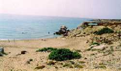
If you aren't already an accomplished wind surfer, you rent equipment and take windsurfing lessons. The airport comes next following this road. Near it are a few sandy coves, usually deserted. The ancient city of Thaeto is close by.
A bit to the south by road lies ancient Arkessia. Here on the stony headland of Paliokastro rests the Mycenaean acropolis and its Cyclopean walls. The acropolis was inhabited until the late Byzantine period. A colorful mosaic floor may be seen in its 5th Century Church of Aghia Anastassia.
The small fishing village of Finika lies just to the north of Arkassa and has a few sandy beaches, and good inexpensive seafood tavernas. Sponge divers from Kalymnos put in here, so you know the food must be good. Caiques depart from Finika for Kassos, weather permitting. From Finika the paved road forks inland to the villages of Pyles, Othos, Stes, Volada and Aperi, and then the road its way back to Pigadia. A dirt road continues on, high above the sea, to the nicest beach on the west coast Lefkos (white). On the way several deserted beaches beckon the more adventurous from below.
There is also a small offshore islet called Sokastro. The Inland Villages
Apparently one of its families was responsible for the TV series Kojak starring non-other than the now deceased cult-hero Telly Savalas. (I went to school with his niece Cally in Athens, who was pretty cute too!) If that's not enough the village also has a miraculous icon within its new Cathedral built over the Byzantine cemetery.
Unlike some poorer Greek islanders, residents of Karpathos like to decorate their houses somewhat lavishly with colorful items such as carpets, mirrors, lace, paintings and antiques. Their elevated, hand-carved wooden beds (souphas) are locally made. The next village up the road is Volada. It's the site of the castle of the Venetian Cornaros family, who owned the island until 1538. The road ascends to 650 meters and the village of Othos, one of the island's oldest. Othos is high enough to boast of being cool even in summer. Its houses are decorated with carved wooden balconies. Othos produces an island specialty–local red wine, called Othiko krasi. You'll be pleasantly amused by its presumption! Visit the small Ethnographic Museum.
Far north, the inland village of Olympos is a wonderful spot to visit at Easter to see the traditional dances and celebrations. Women still bake bread in outdoor ovens and dress in beautiful traditional garb. This striking village is draped over a mountain ridge topped by windmills. The views are magnificent. The houses are adorned with painted balconies, often stacked one atop the other, and somethimes opened with ancient wooden locks and keys. Stop in the church for a look at the frescoes and iconostasis. Olympos was isolated for so long that people here still use pronunciations and expressions that can be traced back to the Doric and Phrygian dialects. Many of its men are noted musicians, but property is passed down through the mother. From Olympos you can drive all the way north to Avlona, inhabited only in summer by farmers from Olympos who use tooks that would look right at home in a museum. From Avlona you can walk down to Vrykous where there's a tiny chapel and rock-cut burial chambers. Beaches on the Island's East Coast
Bring food and drink because you'll be on your own at Apeia Beach.
Drinking and DiningIn Lefkos, locals recommend the Pine Tree restaurant. There are several good eateries in Pigadia and the smaller towns all have two or three good choices. History
Another of its ancient names was Tetrapolic, after its four ancient cities, today in various states of ruin: Vrykous, Possidion, and Nissyros. Before the 5th Century BC the island was a member of the Athenian League. Later it came under the influence of Rhodes until, with the rest of the Dodecanese, it became subject to the Romans. The parrot fish was so abundant off its coast that Roman emperors had special fleets just to bring parrot fish to the imperial tables. From 1912 onwards it was governed by the Italians until 1948 when it became part of the Greek state. HintsThere's a pretty good nightlife scene in Pigadia, with plenty of music and dancing. Maps
The Complete Details
|

 Karpathos,
the second largest island of the Dodecanese, lies 227 nautical miles from
Piraeus and has a population of 5,500. It has a land mass of 301 sq.
km and a coastline of 160 km.
Karpathos,
the second largest island of the Dodecanese, lies 227 nautical miles from
Piraeus and has a population of 5,500. It has a land mass of 301 sq.
km and a coastline of 160 km. 
 A long narrow, mountainous island, Karpathos
is basically two islands in one. The northern and southern parts were
isolated from one another by a vertebra of cliffs for hundreds of years. Their only contact was by caique.
The north is rugged and mountainous. Most sandy beaches on Karpathos are in the
southern portion of the island, where it's fertile and more European in character. Pigadia is the
capitol and connected to the north by a poor road.
A long narrow, mountainous island, Karpathos
is basically two islands in one. The northern and southern parts were
isolated from one another by a vertebra of cliffs for hundreds of years. Their only contact was by caique.
The north is rugged and mountainous. Most sandy beaches on Karpathos are in the
southern portion of the island, where it's fertile and more European in character. Pigadia is the
capitol and connected to the north by a poor road.  Karpathians still retain many
old island customs and are a treasure for ethnologists. The isolation of the northern village of Olympos created a goldmine of unique traditions. The islanders
are extremely hospitable.
Karpathians still retain many
old island customs and are a treasure for ethnologists. The isolation of the northern village of Olympos created a goldmine of unique traditions. The islanders
are extremely hospitable. 

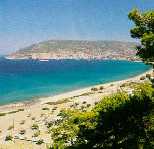 From the harbor, a short walk will bring you to the three km stretch of
beach that lines Vrontis Bay. There you will find a few tavernas and hotels. The columns here on
the sands of Vrontis Bay have been re-erected of the 5th Century
Basilica Aghia Fotini.
From the harbor, a short walk will bring you to the three km stretch of
beach that lines Vrontis Bay. There you will find a few tavernas and hotels. The columns here on
the sands of Vrontis Bay have been re-erected of the 5th Century
Basilica Aghia Fotini.  Seven
km south of Pigadia in Amorfos Bay are the 3 small beach resorts: Small Ampoi, Big Ampoi and Kastellia (the nude
beach). You can reach this area by taking a pleasant walk through olive groves. These sandy beaches are quite popular and reachable by bus,
have hotels, apartments and beach umbrellas. The waters stay shallow
for quite a ways out, making them ideal for young children.
Seven
km south of Pigadia in Amorfos Bay are the 3 small beach resorts: Small Ampoi, Big Ampoi and Kastellia (the nude
beach). You can reach this area by taking a pleasant walk through olive groves. These sandy beaches are quite popular and reachable by bus,
have hotels, apartments and beach umbrellas. The waters stay shallow
for quite a ways out, making them ideal for young children.
 Above
Ammopi on the slopes of Mt. Profitis Ilias lies the colorful village of Menetes with its garden-like environs. It has a small Ethnographic
Museum and has been inhabited since the the 14th Century AD. Menetes has an interesting
church, St. Mamas, in a dramatic setting. It also has several neo-classical buildings.
Above
Ammopi on the slopes of Mt. Profitis Ilias lies the colorful village of Menetes with its garden-like environs. It has a small Ethnographic
Museum and has been inhabited since the the 14th Century AD. Menetes has an interesting
church, St. Mamas, in a dramatic setting. It also has several neo-classical buildings. A
bit further south at Makri Gialos and approaching the southern tip of
Karpathos is a ship wreck and the 'windsurfing paradise' of Afiarti. There are accommodations and a tavern at Afiarti, also known as Devil's Bay.
A
bit further south at Makri Gialos and approaching the southern tip of
Karpathos is a ship wreck and the 'windsurfing paradise' of Afiarti. There are accommodations and a tavern at Afiarti, also known as Devil's Bay. 
 From Menetes the road descends to the west coast of Karpathos
and the port town of Arkassa. Arkassa sits on the slopes of an
impressive ravine possessing many small caves.
From Menetes the road descends to the west coast of Karpathos
and the port town of Arkassa. Arkassa sits on the slopes of an
impressive ravine possessing many small caves. 
 Lefkos is under development but in the meanwhile has lots of pine trees,
some ancient ruins, a taverna or two, rooms to rent and the ruins of a
medieval fort. There
is a bus from Pigadia daily. Many islanders consider Lefkos the jewel of the island because of its horseshoe bays and white sand.
Lefkos is under development but in the meanwhile has lots of pine trees,
some ancient ruins, a taverna or two, rooms to rent and the ruins of a
medieval fort. There
is a bus from Pigadia daily. Many islanders consider Lefkos the jewel of the island because of its horseshoe bays and white sand.  From Pigadia,
the scenic paved road north elevates you first to wealthy Aperi, supposedly the richest village per capita in Greece. Most all its residents
have lived in New Jersey at one time or another and it boasts ninety doctors,
mostly retired.
From Pigadia,
the scenic paved road north elevates you first to wealthy Aperi, supposedly the richest village per capita in Greece. Most all its residents
have lived in New Jersey at one time or another and it boasts ninety doctors,
mostly retired. 


 Further to the west is the village of Pyles (or the unfortunate alternate spelling, Piles) with
lovely views to Kassos and Crete. Sample the local honey here. That's Pyles on the left.
Further to the west is the village of Pyles (or the unfortunate alternate spelling, Piles) with
lovely views to Kassos and Crete. Sample the local honey here. That's Pyles on the left. The first beach north of Pigadia is Ahata. It's small but very clean and with pebbles.
Parts of the road are unpaved but possible with care. There is a taverna.
The first beach north of Pigadia is Ahata. It's small but very clean and with pebbles.
Parts of the road are unpaved but possible with care. There is a taverna.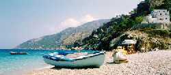 The second beach north of Pigadia is Kyra Panagia. This beach is rocky but has all the amenities and
most of the road is paved.
The second beach north of Pigadia is Kyra Panagia. This beach is rocky but has all the amenities and
most of the road is paved. From
the paved road that took you to Aperi you may descend by dirt road to
Apela Beach but its easier and safer to take a water taxi from Pigadia.
Arrange to be picked up again, too!
From
the paved road that took you to Aperi you may descend by dirt road to
Apela Beach but its easier and safer to take a water taxi from Pigadia.
Arrange to be picked up again, too!  The fourth beach north of Pigadia is Agios Nicolaos. This is a sandy beach close to Arkasa and
may be reached by car or motorbike. On the south side of the island the
water is a couple of degrees lower then on the east side. The waves are
bigger and body surfing is possible. There is a restaurant and sun beds and
parasols for hire by the hour.
The fourth beach north of Pigadia is Agios Nicolaos. This is a sandy beach close to Arkasa and
may be reached by car or motorbike. On the south side of the island the
water is a couple of degrees lower then on the east side. The waves are
bigger and body surfing is possible. There is a restaurant and sun beds and
parasols for hire by the hour. The ancient name of the island was Porfiris, or Red, after a red dye once made on the island which was used to color the clothing of royalty.
 Under Byzantium
it was ravaged several times by pirates. After the capture of Constantinople
by the Turks it fell to the Franks under Leon Gavalas. In 1538 when
it was captured by the Turks. It took part in the War of Independence
in 1821 and enjoyed a brief period of autonomy until retaken by the
Turk in 1832.
Under Byzantium
it was ravaged several times by pirates. After the capture of Constantinople
by the Turks it fell to the Franks under Leon Gavalas. In 1538 when
it was captured by the Turks. It took part in the War of Independence
in 1821 and enjoyed a brief period of autonomy until retaken by the
Turk in 1832. 

©2024 Real Estate in Greece.net | Contact | | Bookmark Sitemap |

