 |
Lasithi Crete
 Coming from Heraklion Province, instead of approaching the Lasithi Plain from the villages of Mohos, Krasi and Kera along the road that branches from Stalidha (as detailed in the Heraklion Prefecture treatise), you can continue along the coast road past Malia and will soon be on the northwestern edge of Lasithi Prefecture. Coming from Heraklion Province, instead of approaching the Lasithi Plain from the villages of Mohos, Krasi and Kera along the road that branches from Stalidha (as detailed in the Heraklion Prefecture treatise), you can continue along the coast road past Malia and will soon be on the northwestern edge of Lasithi Prefecture.
 The main highway will have cut inland toward Neapoli and Aghios Nikolaos, but the old coast road will continue on to the resorts of Sisi and Milatos. The former has an upper and lower village, the lower on a little harbor with a sandy beach. This is Sisi Paralia, with all the trappings of most beach resorts. To the east is Paralia Milatou (pic right) ('paralia' meaning waterfront), with a pebble beach. It was in a cave not far from here that a large number of Greeks (the numbers quoted vary from 2700 to 3600) took refuge during rebellions against the Turks during the early years of the Greek War of Independence. Forced to surrender, the Greeks were promised safe conduct, but instead the men and children were massacred and the women taken as slaves. There is a small chapel at the cave's entrance, with an ossuary containing the victims' bones. It is one of the great ironies of history that such places of human horror can later become pleasure spots for unknowing revelers from other lands. The main highway will have cut inland toward Neapoli and Aghios Nikolaos, but the old coast road will continue on to the resorts of Sisi and Milatos. The former has an upper and lower village, the lower on a little harbor with a sandy beach. This is Sisi Paralia, with all the trappings of most beach resorts. To the east is Paralia Milatou (pic right) ('paralia' meaning waterfront), with a pebble beach. It was in a cave not far from here that a large number of Greeks (the numbers quoted vary from 2700 to 3600) took refuge during rebellions against the Turks during the early years of the Greek War of Independence. Forced to surrender, the Greeks were promised safe conduct, but instead the men and children were massacred and the women taken as slaves. There is a small chapel at the cave's entrance, with an ossuary containing the victims' bones. It is one of the great ironies of history that such places of human horror can later become pleasure spots for unknowing revelers from other lands.
 In ancient times Milatos had been an important city mentioned by Homer in the Iliad as one of the seven Cretan cities that had sent soldiers to Troy. There are at least a couple of versions in mythology about King Minos' brother Sarpedon, with different reasons for his having left Crete for Asia Minor, where he founded the city of Miletus (whose name is almost the same as that of the city he left behind in Crete). In ancient times Milatos had been an important city mentioned by Homer in the Iliad as one of the seven Cretan cities that had sent soldiers to Troy. There are at least a couple of versions in mythology about King Minos' brother Sarpedon, with different reasons for his having left Crete for Asia Minor, where he founded the city of Miletus (whose name is almost the same as that of the city he left behind in Crete).
Though many will take the paved road from here toward Neapolis, there are old dirt roads that go there as well, and others around the Aghios Ioannis peninsula. Neapolis was the old capital of Lasithi province before Aghios Nikolaos. It is a pleasant town with almond groves and a green central square, as well as a museum (open Tues-Sun 10am-1pm and 6-9pm) with traditional craft items and some finds from Dreros. The Heraklion Archaeological Museum houses the hammered bronze statues (the oldest in Greece) found there in a seventh-century BC Temple of Apollo Dhelphinios (one of the oldest temples found in Greece). The name 'Dhelphinios' comes from the cult surrounding Apollo in the form of a dolphin (dhelfini), which was the form he took when guiding sailors. The delphic cult existed in Miletus in Asia Minor, echoing the story about King Minos' brother who had gone there to found that city.
Found in the same temple were Eteocretan inscriptions (Minoan words in Greek letters).
The Lasithi Plain
  Really a round plateau, like a bowl, ringed by mountains. The soil that has created the brilliant green patchwork of crops in the bowl has come down from those mountains, and potatoes, pears, figs, apples, olives, cereals, are all grown there. The villages sit higher up along the rim of the bowl, hence avoiding the spring floods (from melted snow) and in summer the windmills pump water back up to the drier land. Though there are still some of the old cloth-sailed , stone wind-mills still working (also for grinding wheat), most have been replaced with gas-run pumps since the 1970s. The Venetians built 10,000 of them for irrigation of orchards during the fifteenth century after a century-long ban on cultivation and pasture following rebellions by the Cretans, during which the Venetians banished all of them, destroyed their villages and guarded the passes to keep them out. Really a round plateau, like a bowl, ringed by mountains. The soil that has created the brilliant green patchwork of crops in the bowl has come down from those mountains, and potatoes, pears, figs, apples, olives, cereals, are all grown there. The villages sit higher up along the rim of the bowl, hence avoiding the spring floods (from melted snow) and in summer the windmills pump water back up to the drier land. Though there are still some of the old cloth-sailed , stone wind-mills still working (also for grinding wheat), most have been replaced with gas-run pumps since the 1970s. The Venetians built 10,000 of them for irrigation of orchards during the fifteenth century after a century-long ban on cultivation and pasture following rebellions by the Cretans, during which the Venetians banished all of them, destroyed their villages and guarded the passes to keep them out.
There is a ring of eighteen villages around and above the plateau, the largest of which is Tzermiado with a population of about 1500. Trapeza was a sacred cave dating from 5000 BC where votive offerings were left, which was used as a burial ground during Minoan times.
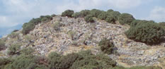
Karphi Minoan settlement
 The highest Minoan peak sanctuaries were found on Mt. Karphi ('karphi' being a nail) an hour's hard hike up the mountain, at 1160 meters/3,800 feet. The southeast slope of this spire-like mountain had been a refuge in 1100 BC for 3000 Minoan's during the Dorian invasions of the time and the village built there one of the last stands of Minoan civilization. Excavated during the late 1930s, 150 single-story stone houses were found, along with a chieftain's house, a temple, a tower, and a shrine with some of the last goddess figurines, the latter dating to around 1050 BC, and housed in the Heraklion archaeological museum. The highest Minoan peak sanctuaries were found on Mt. Karphi ('karphi' being a nail) an hour's hard hike up the mountain, at 1160 meters/3,800 feet. The southeast slope of this spire-like mountain had been a refuge in 1100 BC for 3000 Minoan's during the Dorian invasions of the time and the village built there one of the last stands of Minoan civilization. Excavated during the late 1930s, 150 single-story stone houses were found, along with a chieftain's house, a temple, a tower, and a shrine with some of the last goddess figurines, the latter dating to around 1050 BC, and housed in the Heraklion archaeological museum.
 These terra cotta figurines were strange idols, a full meter tall with long necks and removable feet, though with the familiar upraised arms. There were paved alleys in this village and a hand-grindstone found there. The site was peacefully evacuated in 1000 BC after perhaps an entire century of occupancy.
Up on these high mountain peaks you may get to see some fantastic birds of prey such as the griffon vulture or even the lammergeier (bearded vulture, which has been close to extinction). These terra cotta figurines were strange idols, a full meter tall with long necks and removable feet, though with the familiar upraised arms. There were paved alleys in this village and a hand-grindstone found there. The site was peacefully evacuated in 1000 BC after perhaps an entire century of occupancy.
Up on these high mountain peaks you may get to see some fantastic birds of prey such as the griffon vulture or even the lammergeier (bearded vulture, which has been close to extinction).
 The Dhiktean Cave Legend has it that this cave (left) was the birthplace of Zeus, born there to Rhea, wife of the Titan Kronos, who had overthrown his own father, Ouranos (the Greek word for 'sky') and then eaten all of his own offspring so that he would not be overthrown in turn by a son, a fate of which he had been warned. When Zeus was born, however, Rhea gave Kronos a stone to swallow instead of her newborn, hid the baby in this cave, and had the warriors called Kouretes stand outside and clash their swords and shields together to drown out the baby's cries. Zeus spent his boyhood in the Idhean cave and later poisoned Kronos, who then vomited up all of the swallowed offspring and their help and that of the giant Cyclops, threw Kronos and the Titans from Mt. Olympos. The cave itself was found in the 1880s, and in Paleokastro the 'Hymn of the Kouretes', which connected it with the legend. Certain geological features of the cave supposedly represent elements of the Zeus legend, such as stalagmites that resemble teats (above). The Dhiktean Cave Legend has it that this cave (left) was the birthplace of Zeus, born there to Rhea, wife of the Titan Kronos, who had overthrown his own father, Ouranos (the Greek word for 'sky') and then eaten all of his own offspring so that he would not be overthrown in turn by a son, a fate of which he had been warned. When Zeus was born, however, Rhea gave Kronos a stone to swallow instead of her newborn, hid the baby in this cave, and had the warriors called Kouretes stand outside and clash their swords and shields together to drown out the baby's cries. Zeus spent his boyhood in the Idhean cave and later poisoned Kronos, who then vomited up all of the swallowed offspring and their help and that of the giant Cyclops, threw Kronos and the Titans from Mt. Olympos. The cave itself was found in the 1880s, and in Paleokastro the 'Hymn of the Kouretes', which connected it with the legend. Certain geological features of the cave supposedly represent elements of the Zeus legend, such as stalagmites that resemble teats (above).
 The Dhiktean Cave site is open daily from 8:30am-7pm, Oct-March; 2.40euros). The path to the cave starts from the village of Psykhro, beyond the parking area, with mules available for the climb, which is, however only 1km/.62 miles (though rocky and steep). The cave has been made less treacherous for visitors in recent years, but the The Dhiktean Cave site is open daily from 8:30am-7pm, Oct-March; 2.40euros). The path to the cave starts from the village of Psykhro, beyond the parking area, with mules available for the climb, which is, however only 1km/.62 miles (though rocky and steep). The cave has been made less treacherous for visitors in recent years, but the  guides have also been dispensed with, but one of the guards, Petros Zarvakis is a wildlife expert and leads bird-watching/wildflower hikes between April and September in the surrounding mountains and also to the peak of Mt. Dhikti. Ask someone to contact him for you if he's not around. guides have also been dispensed with, but one of the guards, Petros Zarvakis is a wildlife expert and leads bird-watching/wildflower hikes between April and September in the surrounding mountains and also to the peak of Mt. Dhikti. Ask someone to contact him for you if he's not around.
A thirteenth-century monastery, Moni Kroustallenia (right) (meaning 'Crystal Monastery') is close by, with wonderful panoramic views. There is a folk museum in Aghios Yiorgos, in an old house, with photos of Nikos Kazantzakis and items of all kinds used in everyday Cretan life (June-Aug 10am-4pm).
Aghios Nikolaos
 This is the largest little port town of eastern Crete has grown since the port expanded in 1965. Previously there was no adequate berths, and boats had to dock at Pahia Ammos to the east. After that, things took off and its really quite a pleasant place. The setting is dramatic, with an amphitheater-type village looking down on a round lake as well as the sea, and the stunning Mirabello Bay. There was, in fact, a This is the largest little port town of eastern Crete has grown since the port expanded in 1965. Previously there was no adequate berths, and boats had to dock at Pahia Ammos to the east. After that, things took off and its really quite a pleasant place. The setting is dramatic, with an amphitheater-type village looking down on a round lake as well as the sea, and the stunning Mirabello Bay. There was, in fact, a  port here in ancient times, called Lato, over-looking the islet of Agios Pandes, where the indigenous kri-kri goats live. Lake Voulismeni (left) (whose name comes from the Greek word for drowning), though often called 'bottomless' is actually 210 feet deep. It was connected with the sea in 1867 by the local pasha, having previously been stagnant. port here in ancient times, called Lato, over-looking the islet of Agios Pandes, where the indigenous kri-kri goats live. Lake Voulismeni (left) (whose name comes from the Greek word for drowning), though often called 'bottomless' is actually 210 feet deep. It was connected with the sea in 1867 by the local pasha, having previously been stagnant.
Bars and eating places surround both lake and port. Touts ruin the atmosphere and will, much like lemmings encourage you to dine as you saunter around the lake which may be exited by stone stairways too so you don't have to run the gauntlet twice.
Desirable beaches are few and the better ones taken up by hotels. There is a small sandy beach at Ammoudi at the end of the Koundourou Akti, and on the other end of town near the bus station is Ammos. The public beach, which costs to go to, is crowded; but from there one can walk to Gargardoros Beach and to Almyros, the last being the best near town.
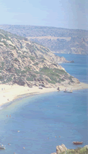
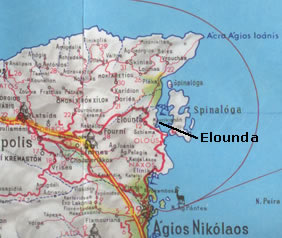
 Better beaches are farther afield, notably at Elounda the the north, with its Spinalonga islet, and there is some scenic countryside in that area to explore on foot or scooter. The coast between Aghios Nikolaos and Elounda (12km/7.4 miles) is very beautiful, with marvelous views across the bay and of the islands in the bay, though expensive hotels occupy the coves below the cliffs. There is a Spinalonga promontory on the south edge of Elounda (not the islet!) with a bridge crossing an artificial channel to the Cretan mainland (dug by the French in 1897). There is a sunken harbor here, Olous by name, which was the port of ancient Driros (above right), to which there are excursions from Aghios Nikolaos. There is a wooden cult statue (supposedly made by Daedalos) of the Minoan moon goddess Britomartis here. According to myth, King Minos chased her incessantly all around the island for nine months until she threw herself into the sea and was rescued in a fisherman's net, from which set of events she earned the name 'Dhikyna' (a dhiktio being a net). There is a Byantine basilica near the canal with a floor mosaic depicting fish. Better beaches are farther afield, notably at Elounda the the north, with its Spinalonga islet, and there is some scenic countryside in that area to explore on foot or scooter. The coast between Aghios Nikolaos and Elounda (12km/7.4 miles) is very beautiful, with marvelous views across the bay and of the islands in the bay, though expensive hotels occupy the coves below the cliffs. There is a Spinalonga promontory on the south edge of Elounda (not the islet!) with a bridge crossing an artificial channel to the Cretan mainland (dug by the French in 1897). There is a sunken harbor here, Olous by name, which was the port of ancient Driros (above right), to which there are excursions from Aghios Nikolaos. There is a wooden cult statue (supposedly made by Daedalos) of the Minoan moon goddess Britomartis here. According to myth, King Minos chased her incessantly all around the island for nine months until she threw herself into the sea and was rescued in a fisherman's net, from which set of events she earned the name 'Dhikyna' (a dhiktio being a net). There is a Byantine basilica near the canal with a floor mosaic depicting fish.
  The islet fortress of Spinalonga (right) is a half-hour trip by caique from Elounda; from Agh. Nikolaos one hour by excursion boat. The islet was detached by a channel from the promontory just as the promontory itself was detached from the mainland-by the digging of a channel-but in the case of the islet (much smaller than the promontory) the channel was dug by the Venetians in 1579, for the purpose of defending their fortress, which was built over the ancient fort of Olous. They were successful until 1715, when they were forced to surrender to the Turks (by treaty). After 1904, when the Turks were thrown out, the islet became a leper colony and remained so until 1957. It was the last leper colony in Europe. The islet fortress of Spinalonga (right) is a half-hour trip by caique from Elounda; from Agh. Nikolaos one hour by excursion boat. The islet was detached by a channel from the promontory just as the promontory itself was detached from the mainland-by the digging of a channel-but in the case of the islet (much smaller than the promontory) the channel was dug by the Venetians in 1579, for the purpose of defending their fortress, which was built over the ancient fort of Olous. They were successful until 1715, when they were forced to surrender to the Turks (by treaty). After 1904, when the Turks were thrown out, the islet became a leper colony and remained so until 1957. It was the last leper colony in Europe.
 The Aghios Nikolaos Ethnographic Museum (10am-1:30pm daily except Sat. and 7-9:30pm;.90 euros) is worth taking in stamps, embroidery, instruments, icons. The Aghios Nikolaos Ethnographic Museum (10am-1:30pm daily except Sat. and 7-9:30pm;.90 euros) is worth taking in stamps, embroidery, instruments, icons.
The Aghios Nikolaos Archaeological Museum (Tues-Sun 8:30am-3pm; 1.45 euros) is at 68 K. Paleologou, and houses finds from eastern Crete. There is a first-century skull with good teeth, with a gold burial wreath, stone vase with two demons, gold jewelry from Mochlos, the chicken goddess of Myrtos, a phallus-idol from Zakros dating from Neolithic times.
There is an annual arts festival in Aghios Nikolaos, which usually runs from late July to early September, with Cretan traditional dance troupes, Cretan choral groups, classical and modern plays (usually in Greek), and various concerts by Greek musicians and singers. Parties are sometimes given by the sponsors during the festival season (usually around midway and then at the end of September) as a way of expressing appreciation to all the foreign visitors who visit Aghios Nikolaos.
Kritsa about 10km/6.2 miles inland, is touted as a 'traditional village', and though it's highly commercialized, all of the local craft items are sold here (mostly weaving, embroidery and ceramics, rugs) and prices are decent. The village achieved much notoriety by the filming here of 'He Who Must Die' with Melina Mercouri (a 1956 Jules Dassin film). The town is known for big Cretan weddings and even re-plays of weddings for guests who pay to get an idea of what a Cretan wedding is all about, complete with food, drink and folk dancing.
The church of Panaghia Kyra
 Rooms here are better priced than at Aghios Nikolaos as well, and there is a nice plateia. About 2km/1.24miles before you reach Kritsa, is the church of Panaghia Kyra (April-Oct daily 8:30am-2:30pm;2.40 euros) The church, which sits in an olive grove, is one-of-a-kind in all of Crete, with long buttresses, three naves, and a simple bell-tower, and possibly the most complete collection of Byzantine frescoes in Crete, dated from the fourteenth and fifteenth centuries. Many have been touched up a bit. St. Francis, brought by the Venetian Catholics, is represented among the many saints. There are also portraits of the donors with their little daughter, giving us an idea of what medieval Cretans looked like. Rooms here are better priced than at Aghios Nikolaos as well, and there is a nice plateia. About 2km/1.24miles before you reach Kritsa, is the church of Panaghia Kyra (April-Oct daily 8:30am-2:30pm;2.40 euros) The church, which sits in an olive grove, is one-of-a-kind in all of Crete, with long buttresses, three naves, and a simple bell-tower, and possibly the most complete collection of Byzantine frescoes in Crete, dated from the fourteenth and fifteenth centuries. Many have been touched up a bit. St. Francis, brought by the Venetian Catholics, is represented among the many saints. There are also portraits of the donors with their little daughter, giving us an idea of what medieval Cretans looked like.
 Past the church is the archaeological site of Lato (right) (Tues-Sun 9am-3pm; closed first Sun of the month;free) with the remains of a seventeenth-century BC Doric city (actually called Lato Etera), situated on a saddle between two hills with great views in several directions. It was named for the Minoan goddess Leto (Lato in the Greek of the Dorians). Though a large site, it has been neglected in favor of Minoan sites, despite the fact that it illustrates many Minoan influences on Dorian architecture. It is a very impressive site, including a temple (most likely to Leto), an altar, and a small theater, and is worth a visit if only for the views. Past the church is the archaeological site of Lato (right) (Tues-Sun 9am-3pm; closed first Sun of the month;free) with the remains of a seventeenth-century BC Doric city (actually called Lato Etera), situated on a saddle between two hills with great views in several directions. It was named for the Minoan goddess Leto (Lato in the Greek of the Dorians). Though a large site, it has been neglected in favor of Minoan sites, despite the fact that it illustrates many Minoan influences on Dorian architecture. It is a very impressive site, including a temple (most likely to Leto), an altar, and a small theater, and is worth a visit if only for the views.
Heading East from Aghios Nikolaos
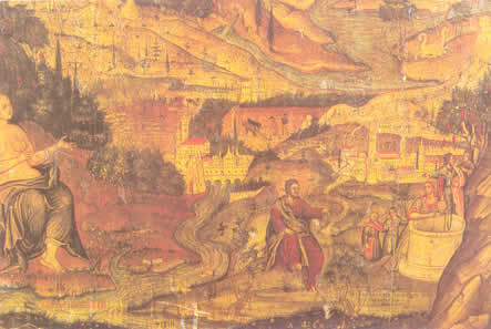
The landscape is rather barren going south along the Gulf of Mirabello and then northeast towards Sitia, but it is worth going up the long uphill road to the right 5km/3.1 miles beyond Kalo Horio, a 6km climb to the monastery Moni Faneromeni. The stunning gulf views along the way are climaxed by the view from the monastery itself, among the most spectacular in Crete, though the buildings are rather drab. The chapel built into a cave sanctuary, however, as well as the frescoes, make up for this. The most impressive is that of the Panaghia Theokotou, the Mother of God. There is an icon of the Virgin here which was found by a shepherd, said to have miraculous powers, and it was due to this discovery that the monastery was built. Sometimes it takes repeated loud knocking to get the attention of the monks who will then let you in. A modest contribution to the monastery may get you more time with the frescoes as well.
Minoan Gournia
 Going back down to the coast road, you come to Istro, a resort with a hotel that hangs on the edge of the cliff and has its own very nice sandy beach in a cove below. Most likely you can just walk through the grounds and go on down and no one will stop you. A little further on you
come to the site of Gournia (open Tues-Sun 8:30am-3pm, 1.45euros). This site (pic below), known as 'the Pompeii of Minoan Crete' is the best-preserved Minoan town. Going back down to the coast road, you come to Istro, a resort with a hotel that hangs on the edge of the cliff and has its own very nice sandy beach in a cove below. Most likely you can just walk through the grounds and go on down and no one will stop you. A little further on you
come to the site of Gournia (open Tues-Sun 8:30am-3pm, 1.45euros). This site (pic below), known as 'the Pompeii of Minoan Crete' is the best-preserved Minoan town.
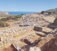 Many small houses with cobbled alleys and stairways surround a square, with one more luxurious house that was probably that of the town ruler, sometimes referred to as a palace, though the entire place is on a much smaller scale than the famous Palace complexes. Most of the houses, which likely had more than the one-story that remained, were made of stone on the lower parts of walls and mud-brick above, with plaster and reeds for the roofs. Many kind of crafts are seen to have been practiced in this town, evidenced by tools and materials discovered there, among them work with clay, metal, and wood. Many small houses with cobbled alleys and stairways surround a square, with one more luxurious house that was probably that of the town ruler, sometimes referred to as a palace, though the entire place is on a much smaller scale than the famous Palace complexes. Most of the houses, which likely had more than the one-story that remained, were made of stone on the lower parts of walls and mud-brick above, with plaster and reeds for the roofs. Many kind of crafts are seen to have been practiced in this town, evidenced by tools and materials discovered there, among them work with clay, metal, and wood.
The site was occupied as early as the third millennium BC, but the town is from the late Minoan period, around 1550 BC, the town was destroyed by fire around 1225 BC and never truly rebuilt, though there was some of this during Mycenaean times.
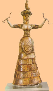 There was also a small theatre area and a Shrine of the Snake Goddess with tubular vases that resembled snakes. This site is also notable for the fact that it was excavated by the first woman in charge of a major dig - Harriet Boyd-Hawes, an American, who worked there from 1901 to 1904. Sir Arthur Evans (excavator of Knossos) had suspected earlier that something was there. There is a campsite with its own cove and a swimming pool as well not far from the site, but this stretch of bay, including the beach at the resort of Pahia Ammos, seems to attract most of the floating garbage from Crete's north coast coast. Hopefully things will be improved by the time you get there. There was also a small theatre area and a Shrine of the Snake Goddess with tubular vases that resembled snakes. This site is also notable for the fact that it was excavated by the first woman in charge of a major dig - Harriet Boyd-Hawes, an American, who worked there from 1901 to 1904. Sir Arthur Evans (excavator of Knossos) had suspected earlier that something was there. There is a campsite with its own cove and a swimming pool as well not far from the site, but this stretch of bay, including the beach at the resort of Pahia Ammos, seems to attract most of the floating garbage from Crete's north coast coast. Hopefully things will be improved by the time you get there.
Just 5km/3.1 miles south of Pahia Ammos is Vassiliki (visible from the main road), where the first examples of Vasiliki ware (housed in the Iraklion archaeological museum as well as the one in Aghios Nikolaos) were discovered, which represented a uniquely Minoan pottery style, with red and black mottling.
At this site was a pre-Palace settlement dating from 2650 to 2200 BC., abandoned after a fire destroyed it in 2200BC, which made it more accessible to excavation. One of its two main buildings, The Red House, had its corners facing the cardinal points of the compass, a common practice in the Near East and Mesopotamia, but not in Egypt or the Aegean. Clues to early Minoan building styles were gleaned from what appeared to be post-holes for wooden beams. Archaeologists have searched for a Minoan palace site in this vicinity since Gournia was more of a settlement than a palace complex and neither is Vassiliki.
Northeast to Sitia
 Heading northeast towards Sitia, the scenery improves vastly and is one of the most exciting stretches of road in Crete, with precipitous drops to the sea, and then the road goes inland at Kavousi. Heading northeast towards Sitia, the scenery improves vastly and is one of the most exciting stretches of road in Crete, with precipitous drops to the sea, and then the road goes inland at Kavousi.
 At Platanos is a turret from which to view the gulf, and some tavernas. Mokhlos (right) is one of the few beaches (pebble type rather than sand) you will see below the road that is accessible, 5km/3.1 miles of switchbacks downhill. At Platanos is a turret from which to view the gulf, and some tavernas. Mokhlos (right) is one of the few beaches (pebble type rather than sand) you will see below the road that is accessible, 5km/3.1 miles of switchbacks downhill.
It is more of a fishing village than a resort, with some rooms (including fairly cheap ones) and some tavernas. There is a small islet (right) also called Mochlos, very close to shore which was once attached to the Cretan mainland and which had Minoan houses on it, remains of which can be seen on the islet's south side. Pots were made in Mokhlos with lids handles shaped like reclining dogs. Seven tombs were found in the cliffs here fairly recently, dug into the rock, and surprisingly intact. Important finds from these tombs were early seal stones including one from Mesopotamia, gold jewelry (in the Iraklion archaeological museum) and vases made from marble, rock crystal, and steatite (in the Aghios Nikolaos and Sitia archaeological museums). Pot shards from Akrotiri (the destroyed village excavated on Santorini) were found here as well. Mokhlos was abandoned after the disasters of 1470 BC. The waters are very clear here and there are places to camp out.
Offshore 2km/1.24 miles if the island of Pseira. This was also a Minoan port, excavated in 1907 by Richard Seager, an American archaeologist.
It was a prosperous town built like an amphitheater around a harbor with steps leading upward to the houses, each of which had a hearth in one room There was a shrine here with a floor that had been built up with pumice that had drifted from Santorini (Thera). One of loveliest houses in eastern Crete was found here-the House of the Pillar Partitions-with a sunken tub in the bathroom and a drain for the water. Exceptional painted pottery was also found here, one of the most famous of which is the jar (at the Heraklion Archaeological Museum), with bull's heads and double axes. The island was later used by the Romans, who had a lighthouse and military settlement at the highest point.
 From this narrowest point of Crete, (only 12km/7.5miles) the road to Ierapetra heads south or east en route to Sitia one passes villages on the cliffs overlooking the sea, among which Mirsini stands out, with its church built around a fourteenth-century chapel with frescoes. From this narrowest point of Crete, (only 12km/7.5miles) the road to Ierapetra heads south or east en route to Sitia one passes villages on the cliffs overlooking the sea, among which Mirsini stands out, with its church built around a fourteenth-century chapel with frescoes.
There is also a pottery and weaving workshop as well as a taverna with spectacular views. After Mirsini, look for the Minoan site of Hamezi on a sign-posted dirt-road to the right. You can walk in and get to the site, which sits on a hilltop, in fifteen minutes, turning right a second time after the windmills and from there you can see the site, which has a fence around it. The stone ruin dates from around 2000BC, and is unique due to its oval ground plan. It may have been a house, or a fortress. Several rooms surround a courtyard with a cistern. Again-this site is worth going to if only for the views. The village by the same name is a pleasant place, with a folk museum at the church. There are tholos tombs at Akhladia (which means 'pears'), dating from Mycenaean times and a Minoan villa (neo-Palatial period). There is a second Moni Faneromeni just before Sitia (and just after Skopi. (There are, in fact, many monasteries with this name, 'moni' meaning monastery, and 'faneromeni' having to do with revelation). The church overlooks a gorge not far from the sea. Both monastery and church were sacked and burned by the Turks in 1829, and the frescoes destroyed. One scorched fragment remains.
Sitia
  This main town and port of the eastern isthmus of Crete is also amphitheatrically-arranged, like Aghios Nikolaos, but unlike the latter, it has the reputation of a town that has not succumbed wholly to tourism, despite the fact that it has a long sandy beach (and one accorded the 'blue flag' of ecological purity). The beach is also popular with wind-surfers, and there are plenty of seaside restaurants. There are inexpensive rooms available as well as a good youth hostel in Sitia (on the main road coming from Aghios Nikolaos) with some private rooms and tent space as well in a garden. Another good beach is found at Aghios Fotia, 5km/3.1miles to the east. Camping on the beaches is an option as well, but safest a little ways out from town. This main town and port of the eastern isthmus of Crete is also amphitheatrically-arranged, like Aghios Nikolaos, but unlike the latter, it has the reputation of a town that has not succumbed wholly to tourism, despite the fact that it has a long sandy beach (and one accorded the 'blue flag' of ecological purity). The beach is also popular with wind-surfers, and there are plenty of seaside restaurants. There are inexpensive rooms available as well as a good youth hostel in Sitia (on the main road coming from Aghios Nikolaos) with some private rooms and tent space as well in a garden. Another good beach is found at Aghios Fotia, 5km/3.1miles to the east. Camping on the beaches is an option as well, but safest a little ways out from town.
  There is a large cultural festival here on 24 June, and in mid-August a three-day wine and sultana festival (big products in this area), with traditional dancing. There is a Venetian fort (left) , a folklore museum (open Mon-Sat, 9:30am-5pm 1.45 euros); Roman fish tanks; an archaeological museum (open daily July and August 8:30am-3pm; September-June Tues-Sun, same hours;1.45 euros). The latter includes a wine press, Linear A tablets from Zakros, finds from Petras. There is a Minoan cemetery (pre-Palatial) of 250 chamber tombs was found near the east end of Aghios Fotia, but the area is fenced off. An important figure born here was the seventeenth-century Creto-Venetian Vicenzo Kornaros, who wrote the famous Cretan epic poem , the Erotokritos, which consists of 10,000 lines written in Cretan dialect. It is still sung today, accompanied by lyra and laouto. There is a large cultural festival here on 24 June, and in mid-August a three-day wine and sultana festival (big products in this area), with traditional dancing. There is a Venetian fort (left) , a folklore museum (open Mon-Sat, 9:30am-5pm 1.45 euros); Roman fish tanks; an archaeological museum (open daily July and August 8:30am-3pm; September-June Tues-Sun, same hours;1.45 euros). The latter includes a wine press, Linear A tablets from Zakros, finds from Petras. There is a Minoan cemetery (pre-Palatial) of 250 chamber tombs was found near the east end of Aghios Fotia, but the area is fenced off. An important figure born here was the seventeenth-century Creto-Venetian Vicenzo Kornaros, who wrote the famous Cretan epic poem , the Erotokritos, which consists of 10,000 lines written in Cretan dialect. It is still sung today, accompanied by lyra and laouto.
Monastery of Toplu between Sitia and Vai
 This fortified monastery houses one of the greatest works of Orthodox Greek art in Crete: This fortified monastery houses one of the greatest works of Orthodox Greek art in Crete:
The Icon by Ioannis Kornaros O Lord Thou Art Great.
Behind its forbidding exterior you'll see how the monks really lived in a serene world of stone walled cloisters and flower filled courtyards (9am - 1pm, 2pm - 6pm daily, fee, tel: 28430) The monastery has undergone extensive repairs over the last few years. It was built in the 14th C and dedicated to the Birth of the Virgin and St. John the Theologian. Subsequently under the Venetians it acquired its fortifications. In 1646 the Turks captured it and devastated it for harboring rebels and it suffered again during the war of Independence in 1821.
Vai Beach
 A gorgeous beach (left) with silver sand famous for its palm trees, which are a species unique to Crete (Phoenix theophrastii) and Europe's only wild palm trees. A gorgeous beach (left) with silver sand famous for its palm trees, which are a species unique to Crete (Phoenix theophrastii) and Europe's only wild palm trees.
There is also a banana plantation here! A place that gets mobbed in summer.
To avoid the worst of all that, move onto to the smaller beaches to the north, which also have a few palms and the option of camping out.
Paleokastro
A farming village south of Vai 9km/5.5miles. There are some decent beaches here and some inexpensive rooms as well as camping options. There is a small folk museum here (May-Oct Tues-Sun 8:30am-1pm;free).
Zakros
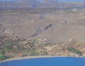 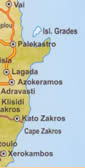 Due south of Vai about 20km/12.4miles from Paleokastro. There is an Ano (upper) Zakros and a Kato (lower) Zakros, the Minoan palace found at the lower one (8km/5 miles) further down. In between the two, you can walk to the Valley of the Dead, which is a gorge (pic right center) which had Minoan tombs (2600BC) carved into its sides. The Palace of Zakros (open April- Sept, Tues-Sun 8am-7pm;Oct-March 8am-3pm;1.45euros) is the fourth largest palace complex in Crete, dated around 1700 BC. Due south of Vai about 20km/12.4miles from Paleokastro. There is an Ano (upper) Zakros and a Kato (lower) Zakros, the Minoan palace found at the lower one (8km/5 miles) further down. In between the two, you can walk to the Valley of the Dead, which is a gorge (pic right center) which had Minoan tombs (2600BC) carved into its sides. The Palace of Zakros (open April- Sept, Tues-Sun 8am-7pm;Oct-March 8am-3pm;1.45euros) is the fourth largest palace complex in Crete, dated around 1700 BC.
It was probably the Minoan's chief port for Egypt. Destroyed (like so many other Minoan palaces and settlements) during the disasters around 1450 BC, but unlike many others, was not looted or rebuilt, and the first major excavations during the 1960s, yielded up cult items and a lot of unworked ivory, everyday items of all kinds, food, pottery, etc.
South to Ierapetra
Heading to the south coast from Sitia and then west towards Ierapetra, one comes across a fishing village with one of eastern Crete's nicest beaches, at Makryialos, but predictably it has gone the touristic path, and become a pricey place to stay. After that, the coast is rocky and plastic greenhouses cover the coastal plain, but there are sandy beaches, including Long Beach, with a good campsite. Aghia Fotia has a good beach and many rooms.
  Ierapetra, which means 'sacred rock', is the largest city on the south coast of Crete, and the southernmost city in Europe. There was most likely a Minoan port or settlement here, but later it became a powerful Doric city in Hellenistic times, called Ierapytna. which was the final nail in the coffin of Minoan civilization in eastern Crete. Under the Romans, who conquered the entire island, with Ierapytna the last holdout (but which finally gave way as well), it became a big trade center in the eastern Mediterranean, with Crete now part of the province of Cyrenaica, which included northern Libya (where Cyrene was located). Later it was a Byzantine bishopric, was pillaged by the Saracens, and was destroyed by an earthquake in 1508. No one has much good to say about present-day Ierapetra, which is mainly a farm-supply center with a decent waterfront and some beaches to the east that have been awarded the EU blue flag (meaning that they are clean and unpolluted). The town used to attract a lot of people looking for agricultural work during the off-season, and despite its not being an exciting place, it gets some package tourism. There is a thirteenth-century Venetian Kastelli (fort) along the seafront (open 9am-9pm) and the fourteenth century church of Afendi Christos, with a wooden iconostasis. The Archaeological Museum is well worth a visit (Tues-Sat 8am-3pm;1.50euros). There is also a Tzami (Turkish Mosque with a minaret. Ierapetra, which means 'sacred rock', is the largest city on the south coast of Crete, and the southernmost city in Europe. There was most likely a Minoan port or settlement here, but later it became a powerful Doric city in Hellenistic times, called Ierapytna. which was the final nail in the coffin of Minoan civilization in eastern Crete. Under the Romans, who conquered the entire island, with Ierapytna the last holdout (but which finally gave way as well), it became a big trade center in the eastern Mediterranean, with Crete now part of the province of Cyrenaica, which included northern Libya (where Cyrene was located). Later it was a Byzantine bishopric, was pillaged by the Saracens, and was destroyed by an earthquake in 1508. No one has much good to say about present-day Ierapetra, which is mainly a farm-supply center with a decent waterfront and some beaches to the east that have been awarded the EU blue flag (meaning that they are clean and unpolluted). The town used to attract a lot of people looking for agricultural work during the off-season, and despite its not being an exciting place, it gets some package tourism. There is a thirteenth-century Venetian Kastelli (fort) along the seafront (open 9am-9pm) and the fourteenth century church of Afendi Christos, with a wooden iconostasis. The Archaeological Museum is well worth a visit (Tues-Sat 8am-3pm;1.50euros). There is also a Tzami (Turkish Mosque with a minaret.
 Gaidouronisi (Donkey Island, picture right) is an uninhabited islet 10km/6.2 miles offshore with a natural cedar forest, tavernas and good sandy beaches. Koufonisi a more distant island to the east with murex seashells that were used for royal purple dye (for cloth) and very clear water. Some excavations were carried out here, unearthing a theater and a village. Gaidouronisi (Donkey Island, picture right) is an uninhabited islet 10km/6.2 miles offshore with a natural cedar forest, tavernas and good sandy beaches. Koufonisi a more distant island to the east with murex seashells that were used for royal purple dye (for cloth) and very clear water. Some excavations were carried out here, unearthing a theater and a village.
To the west of Ierapetra is a large recycling plant called Costa Plastica for all of the plastic that the vegetables grow under in the greenhouses. To the northwest of the city is the attractive village of Kalamafka. Back down on the coast on the way to Myrtos is Ammoudares, a beach with greenhouse heaven behind it.
Myrtos is a resort, but of the laid-back type, with reasonable prices and some free camping . There is an archaeological site at what was once Nea Myrtos and is now called Fournou Korifi. This was a Minoan town of sorts, with almost one hundred rooms, inhabited between 2600 and 2100BC, and later destroyed by fire. It was excavated by British archaeologists in 1968. The oldest known Aegean potter's wheel was found here, dated to 2500 BC; stomach contents of the inhabitants that didn't biodegrade (bones, olive stones, etc.) which gave clear information about the Cretan diet of the period; a shrine to the Goddess of Myrtos (housed in the Aghios Nikolaos museum).
|
|
FEATURED PROPERTIES:Ikaria - Armenistis
New Maisonettes
Price: €209,000 - 125 m2
Bedrooms: 3 Baths: 2

|

