Greece Property for Sale - Real Estate In Greece Buy & Sell |
Sell Your Greek Property Fast. Be Listed on the 1st Pages of Google, Yahoo & MSN Learn More - Sign Up! »» |
| Kefalonia Property & Houses For Sale - Real Estate In Greece 0 Property(s) Found - Page 1 of 0 - Updated: 4/26/2024 |
|
FEATURED PROPERTIES: Ikaria - Armenistis New Maisonettes Price: €209,000 - 125 m2 Bedrooms: 3 Baths: 2  |
KEFALONIA
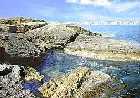
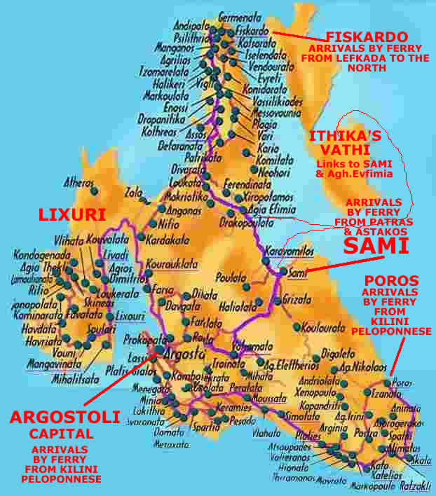
Kefalonia CharacteristicsLargest of the Ionian Islands, Kefalonia has a land mass of 728 sq.km and 254 km of coastline. Its population is over 32,000. It is 56 nautical miles from Patras. Its Capital is Argostoli, and its main port, Sami. The highest point is Mt Enos (1627m). This is a large island and its easy to escape the tourists but it fills up in summer! Its biggest drawbacks are long distances between places of merit over tortuous mountain roads and the unfortunate cement architecture from the devastation of the 1953 earthquake. Island FeaturesKefalonia is a beautiful, rugged and mountainous island with many diverse geological elementssubterranean caves, sandy beaches, unique fir forests.
Argostoli, Kefallonoa's Capital and the Lassi Peninsula
Many boats are dry docked here in the winter months. Originally a smugglers' hideaway, it grew by virtue of the protection from pirates afforded it by the Venetians into a large warehousing port for the export of raisins. Its narrow traditonal looking streets were actually destroyed by an earthquake in 1953. Post-quake Argostoli received lots of financial help from Kefalonians living abroad and was rebuilt as traditionally as possible under the circumstances. Photos of the destruction and rebuilding are housed in the Historical and Folk Museum. It has a plethora of public buildings grouped around its central square. Platia Vallianou and two of its famous bell towers have been rebuilt. The Archeological Museum on George Vergoti St. which runs parallel to the harbor, (8:30-3, closed Mon, fee.Tel: 28300) contains many finds from around Kefalonia. Ivory and gold statues, votive offerings to Pan from the Cave of Melissani, coins from the ancient city-states and loads more.
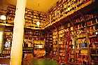
The Historical and Folklore Museum on 12 Ilia Zervou St. (9-2, closed Sun, fee) is particularly interesting in light of the hints contained therein as to pre-quake Kefalonia. Many pictures, maps, furniture, icons, memorabilia as well as the Venetian's island records are on display. The only structure to survive Kefalonia's earthquake intact in Argostoli was the British-built Drapanos Bridge. You can see the bridge from the waterfront.
The Lassi Peninsula on which Argostoli sits has a few sandy beaches, disco bars and tavernas. It's traditional when visiting Kefallona to hike or bike around this tiny peninsula just north of the city. In its north there are Katavothres or swallow holes. Geologists poured 150 kilos of green die down the holes to see where the water emerged and found out fifteen days later across the island near Sami in the cave lakes of Melissani and Karavomylos.
A brisk 15 minute walk inland will bring visitors to the WW II Memorial to the Italian soldiers who lost their lives fighting the Nazis. To the south of Argostoli are some wonderful beaches but commercialized with package tours–Plati Gialos and Makris Gialos. Here are two of the island's most luxurious hotels–The Mediterranee and the White Rocks. S. E. of Argostoli, Lavatho and Mt. Ainos
Inland Villages of the Plain of Omalos
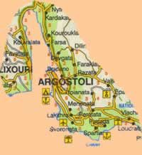
Megas Soros (1628m) is the highest peak in the Ainos Range of mountains its airs are the most rarified of all the Ionian islands. The Argostoli-Sami road branches towards its summit and ascends to 1300m and the tourist pavilion from which you may hike to the top. From here on a clear day may be seen the whole shebang: The Peloponnese, Corfu, Zakynthos, Lefkada and Ithaki. A unique species of black fir, Abies cefalonica covered these slopes at one time but due to two major fires and exports nine-tenths have been lost. The trees now form the Mt. Ainos National Park. The forests were so extensive that ancients called the island Melania or "the Dark." An ancient, almost extinct, breed of wild horses also roams the park. Just below lies the 8th Century BC Temple of Aenesian Zeus where still lie the bones of animal sacrifices. Lixouri and the Paliki Peninsula
Some nice local, non built-up beaches are accessible from the peninsula: Aghios Spyridon, Michalitsata, Lepeda are all sandy. From the village of Mantzavinata a dirt road leads south to a long stretch of golden sand and Palliki's best known beach Xi which features umbrellas and tavernas.
The South Coast of Kefalonia
Kato Kastelios is a small resort with a pretty beach curving along Mounda Bay. Just below Ratzakli village is Potamaki beach and a nesting place for protected loggerhead turtles. Please leave the turtles to themselves! The village of Markopoulo, just inland, is the yearly scene of the appearance of thousands of harmless baby snakes with small crosses on their heads. The appear at the beginning of August and disappear into the church by the altar near the silver icon of the Panagia Fidon (Virgin of the Snakes). At least that's what they did before the quake. Now villagers pick them up to protect them from motorists and gawkers, put them in glass jars and after the service deposit them within the church, which was rebuilt in exactly the same spot as before. They disappear just as in pre-quake days. The unfaithful claim that the church is simply on the reptiles' migratory route, while the faithful point out that the snakes fail to appear when the island is in trouble such as the year of the earthquake (1953) and during the German occupation. Skala is the biggest resort in this section of the island with all the amenities but still not too overblown. Inland, above Pastra are the remains of the ancient city of Pronnoi with little to be seen. Close by, however, in 1992, at the hamlet of Tzanata, archeologists discovered the main contender to the Tomb of Odysseus status deep below (7m) a vineyard. These 12th Century BC finds are called the most important ancient tombs in western Greece. There were bones, sigil's and gold jewelry. Unfortunately they can't be viewed, since they are all under study at the University of Patras. From Tzanata the road descends through the Poros gap to Poros where ferries link to Kilini on the Peloponnese. This was originally the port of the ancient town of Pronnoi. Poros has a beach and is under development. The Port of Sami and Northern Kefalonia
The more expensive, prettier and better cave is the Purple Cave or Melissani Cave, a half hour walk from Sami. This is the one connected to the swallow holes across the island and thought by some to be the Cavern of the Nymphs referred to by Homer. This subterranean cave-lake has vivid blue waters in a channel leading to the enclosed section where the nymph Melissani drowned herself when she was spurned by Pan. Sunlight filters down through a hole in the roof making it rather attractive. There are a variety of other undeveloped caves available to spelunkers in the Sami area but are dangerous to the untrained. Angela cave near Poulata is reputed to be the best.
Up the Coast to Mytros, Assos and Fiskardo
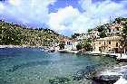
Assos is perhaps the prettiest spot on the island and here were filmed many of the sunset scenes from the movie Captain Corelli's Mandolin. The whitewashed and pastel houses of Assos straddle the isthmus of a peninsula. This tiny fishing village of 85 residents gets overwhelmed in season and the reasons are obvious. It sits at the bottom of a steep and winding road tucked in the cranny of the isthmus and a a huge rock topped by a Venetian castle. No beaches exist but there are small coves accusable by boat. The Castle may be reached after a serious climb but is worth it for the views. A car can get you up as well. The village was destroyed in the earthquake but rebuilt by French funds which did a pretty good job in keeping with its natural surroundings. At night when the day trippers leave, it returns to its small Greek fishing village persona, although many yachties may berth there for overnights. The castle is in a state of ruin but quite a bit remains. During WWII, 1,500 Italian troops were lined up and shot by the Nazis here. The road continues north to Cape Ather and passes several villages on the way to picturesque Fiskardo, (pop 100) which was spared the earthquakes wrath but has turned into a trendy over-hyped tourist attraction with little charm in season. There are one or two shingle beaches to either side but better ask the way. There are many over priced tourist shops. Off season is the time to visit Fiskardo, not July or June. Drinking and DiningIn Argostoli, the areas around the fruit market by the harbor have several good unpretentious tavernas: Taverna Diana, Patsoura and Tzivas near the fruit market. Near the Folklore Museum are two garden restaurants with excellent food and traditional specialties: O Mezes and Sto Psito. In Platia Vallianou, the central square of Argostoli, El Greco, Kefalos and Caliva are dependable. Most of the nightlife is in Argostoli. HistorySome of the oldest tool and artifact discoveries in all of Greece have been discovered on Kefalonia. In Fiskardo at the northern most tip of the island in particular, items over 50,000 years old have been retrieved. Somewhat later inhabitants seem related to the elusive Pelasgians who also occupied parts of Sicily, Epirus and other Aegean islands long before recorded history. Many of the skulls found on Kefalonia show death by violent means. Mycenaean culture was introduced by the Achaeans via the Peloponnese in the 14th C BC. The main city seems to have been Krani near Argostoli. A major Mycenaean tomb has been discovered near Poros just across from Ithika and archeologists are hoping to discover the Palace or Tomb of Odysseus there. Homer never refers to Kefalonia however, and many think that the island was part of the Kingdom of Odysseus and therefore known as part of Ithika. Herodotus and Thucydides make first written reference to Kefalonia and its 4 independent city-states of Sami, Pali, Krani and Pronnoi all of which opposed Athens and were allied with Corinth. The Byzantine period was good for Kefalonia, despite many piratical incursions from Sicily and as far away as Spain. The Normans under Duke Robert Guiscard unsuccessfully attempted to rest control of Kefalonia from the Byzantines but were rebuffed. The Duke died of fever in the current yacht haven of Fiskardo, which is actually named after him, but Grecianized. He was the terror of his day who sacked Rome and made emperors and kings quake in fear.
In 1483 the expanding Turkish Empire captured Kefalonia only to lose it again in 1504 to the Venetians and their Spanish allies under Gran Capitan Gonzalo Fernandez de Cordoba who captured the the fort of Aghios Georgos and slaughtered the Turkish garrison. After repairing the fortress the nearby town became the Venetian capital but was destroyed and later abandoned after the earthquake of 1636. Argostoli became the capital in 1759.
The British occupied Kefalonia and the Ionian islands for many years after the Turkish withdrawal and when in 1849 the Kefalonians revolted and demanded union with Greece. In 1943, during WW II, upon Italy's surrendered to the Allies, the occupying Italian Acqui Division joined the Kefalonian Greeks in fighting the Nazis and for eight days fought off the invasion until all were subsequently massacred in mass executions ordered by The Furher himself. Greeks call them the Martyrs of Keffalonia. Their bodies were burned to hide the evidence but estimates are that between 5 000 and 10,000 Italian soldiers were killed. For 5 days in August 1953 Kefalonia was rocked by a series of earthquakes. In all, 113 tremors turned almost all of Kefalonias' 350 villages and towns into rubble with the force of 60 Atomic bombs emanating from the very first quake. Europe rallied, as did the many Kefalonians who lived abroad and money came pouring in to help the survivors and to rebuild. HintsAfter reading about Kefalonia's turbulent history perhaps you'll enjoy the natural beauty of the island and friendliness of the islanders even more. Assos is recommended. Maps
The Complete Details
|
 It also
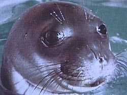
plays host to loggerhead turtles and the Mediterranean Monk Seal, one
of the 6 rarest animals in the world. Kefalonia has a unique breed of horses. Additionally the island has many species of wild flowers and spice and
produces wonderful wines. The island is especially known for its Robola grape, which produces a lemony dry white wine. New wineries on the island are creating very good Greek wines.
It also
plays host to loggerhead turtles and the Mediterranean Monk Seal, one
of the 6 rarest animals in the world. Kefalonia has a unique breed of horses. Additionally the island has many species of wild flowers and spice and
produces wonderful wines. The island is especially known for its Robola grape, which produces a lemony dry white wine. New wineries on the island are creating very good Greek wines. 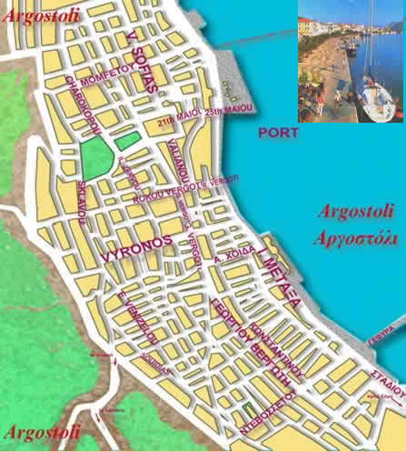 Big, busy Argostoli sits on a promatory jutting into Kefalonia's long and narrow bay. The bay's
deep waters making it an ideal port town.
Big, busy Argostoli sits on a promatory jutting into Kefalonia's long and narrow bay. The bay's
deep waters making it an ideal port town. 

 Once over the bridge, the road passes,
on its way to Sami, via the village of Razata where a dirt road leads
up to the 7th Century BC ancient city of Krani or Paliokastro (old castle). Remains of a Doric Temple to Demeter and lengths of the
Cyclopean walls are to be seen there.
Once over the bridge, the road passes,
on its way to Sami, via the village of Razata where a dirt road leads
up to the 7th Century BC ancient city of Krani or Paliokastro (old castle). Remains of a Doric Temple to Demeter and lengths of the
Cyclopean walls are to be seen there. 
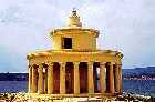
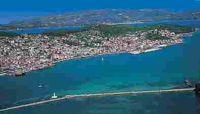 At the tip
of the peninsula is the Lighthouse of Aghio Theodori, a Doric Rotunda
funded by British High Commissioner Charles Napier. (picture above in the center)
At the tip
of the peninsula is the Lighthouse of Aghio Theodori, a Doric Rotunda
funded by British High Commissioner Charles Napier. (picture above in the center) 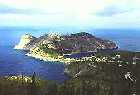 Once
past the overbuilt Piati Gialos and Makris Gialos, the coastal road breaks
free and the village of Minies appears. Minies holds the ruins of a 6th
Century BC Doric Temple. You are in wine country in this area. Continuing
on will bring you to Avithos beach with red sand, and a few amenities
near the village of Svoronata. Just across the water is the islet of Dias.
Once
past the overbuilt Piati Gialos and Makris Gialos, the coastal road breaks
free and the village of Minies appears. Minies holds the ruins of a 6th
Century BC Doric Temple. You are in wine country in this area. Continuing
on will bring you to Avithos beach with red sand, and a few amenities
near the village of Svoronata. Just across the water is the islet of Dias.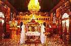 Some
of the oldest Olive trees on the island may found in the next village
of Domata where one tree can actually hold 20 people squeezed
within is hollow trunk. Olive trees can live a few thousand years.
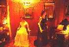
Left, is the Church of the Virgin with some rather ostentatious
real gold baroque decor.
Some
of the oldest Olive trees on the island may found in the next village
of Domata where one tree can actually hold 20 people squeezed
within is hollow trunk. Olive trees can live a few thousand years.
Left, is the Church of the Virgin with some rather ostentatious
real gold baroque decor.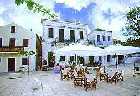 The
village of Kourkomelata is just about all new construction and
financed by Kefalonia's wealthy ship owner Mr. Vergotis. The next village Metaxata hosted Lord Byron for a few months while he polished
up Don Juan and pondered his role as a member of the Greek Committee.
The
village of Kourkomelata is just about all new construction and
financed by Kefalonia's wealthy ship owner Mr. Vergotis. The next village Metaxata hosted Lord Byron for a few months while he polished
up Don Juan and pondered his role as a member of the Greek Committee.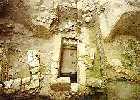 To
the west lies Lakidra, the most important village of the area,
rebuilt largely by French donations. Here were discovered, in the
suburb of Kallithea, near the Church of St. Nikolaous the Aliprantidon four Mycenaean tombs also thought to be by some archeologists the Tomb of Odysseus.
To
the west lies Lakidra, the most important village of the area,
rebuilt largely by French donations. Here were discovered, in the
suburb of Kallithea, near the Church of St. Nikolaous the Aliprantidon four Mycenaean tombs also thought to be by some archeologists the Tomb of Odysseus. North of Metaxata is the
seat of old island administration, the Castle of Aghios Georgos (Open June-Oct, 8:30-7, Sun 8:30-3, closed Mon). This castle spreads extensively over the 320 meter hill and commands a view of
the mountains and surrounding plains. First built by the Byzantines and
then rebuilt after the ousting of the Turks by the Greeks and Venetians
under Nikolas Tsimaras in 1500. It once housed 14,000 souls within its
immediate vicinity.
North of Metaxata is the
seat of old island administration, the Castle of Aghios Georgos (Open June-Oct, 8:30-7, Sun 8:30-3, closed Mon). This castle spreads extensively over the 320 meter hill and commands a view of
the mountains and surrounding plains. First built by the Byzantines and
then rebuilt after the ousting of the Turks by the Greeks and Venetians
under Nikolas Tsimaras in 1500. It once housed 14,000 souls within its
immediate vicinity.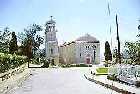 Just below the Castle is
the one time Byzantine Convent of Aghios Andreas. The earthquake of 1953
shook the walls to reveal 13th century frescoes under the whitewash. The
church is now the Museum of Agh. Andreas Monastery (Mon-Fri, 9-1:30/5-8,
Sat 9-1:30, closed Sun) and houses icons, religious tracts, and
a donation of immensurable value by the Princess Roxanne of Epiros–the
sole of St. Andrew's right foot.
Just below the Castle is
the one time Byzantine Convent of Aghios Andreas. The earthquake of 1953
shook the walls to reveal 13th century frescoes under the whitewash. The
church is now the Museum of Agh. Andreas Monastery (Mon-Fri, 9-1:30/5-8,
Sat 9-1:30, closed Sun) and houses icons, religious tracts, and
a donation of immensurable value by the Princess Roxanne of Epiros–the
sole of St. Andrew's right foot.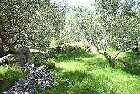 The breadbasket Plain of Omalos lies to the east and the Monastery
of Aghios Gerasimos, the islands patron saint. His bones rest in
a silver reliquary in the small church built over his hermitage. Pilgrims
from all over Greece worship here. The Si.Ro.Ke. winery is just opposite
and sometimes open for wine tasting.
The breadbasket Plain of Omalos lies to the east and the Monastery
of Aghios Gerasimos, the islands patron saint. His bones rest in
a silver reliquary in the small church built over his hermitage. Pilgrims
from all over Greece worship here. The Si.Ro.Ke. winery is just opposite
and sometimes open for wine tasting.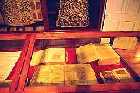
 From Argostoli, ferries make the trip
across the strait to Lixuri in about half an hour. Lixouri is known for its sense of humor and for being home to the poet and satirist Andreas Laskaratos. Lixuri is now a working community,
the highlight of which is the elegant Iakovatos Mansion. An
icon museum and library, it is one of the few survivors of the earthquake
and offers a revealing look at how beautiful things must have been compared to
what they are today. On the west side of town, its hours are 8-1:30 Mon-Fri,
9:30-12:30 Sat.
From Argostoli, ferries make the trip
across the strait to Lixuri in about half an hour. Lixouri is known for its sense of humor and for being home to the poet and satirist Andreas Laskaratos. Lixuri is now a working community,
the highlight of which is the elegant Iakovatos Mansion. An
icon museum and library, it is one of the few survivors of the earthquake
and offers a revealing look at how beautiful things must have been compared to
what they are today. On the west side of town, its hours are 8-1:30 Mon-Fri,
9:30-12:30 Sat. Just to its south is the now stationary Monolith of Kounopetra. It used to vibrate before the quake. To the north are the villages of Kaminarata, Delaportata and Damoulinata.
The beach of Petani has nice white sand and almost is deserted. At the
northern tip of the peninsula is beach Aghios Spyridon II.
Just to its south is the now stationary Monolith of Kounopetra. It used to vibrate before the quake. To the north are the villages of Kaminarata, Delaportata and Damoulinata.
The beach of Petani has nice white sand and almost is deserted. At the
northern tip of the peninsula is beach Aghios Spyridon II.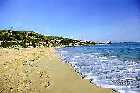 There are loads of good
sandy, sheltered beaches to be found here in the lee of Megas Soros including Spartiaand
Pessada. Below Karavados village, Lourdata is the most popular and longest
beach. This beach is also beginning of the Nature Trial, funded by the WWF. A 2.5
hr walk which encompasses most of the island's fauna and passes the
ruined Monastery of St. Francis of Assis founded in 1218.
There are loads of good
sandy, sheltered beaches to be found here in the lee of Megas Soros including Spartiaand
Pessada. Below Karavados village, Lourdata is the most popular and longest
beach. This beach is also beginning of the Nature Trial, funded by the WWF. A 2.5
hr walk which encompasses most of the island's fauna and passes the
ruined Monastery of St. Francis of Assis founded in 1218.  Sami is a utilitarian port
town with its own beach and campsite but little else in the way of interest. Ferry traffic goes from Sami to Patras, Corfu and Italy.
People often stay overnight here because the nearby caves and beaches are worth a visit. Four km east is one of the nicer beaches of the eastern coast: Andisamos. Because it has only has a small cantina, Andisamos keeps the crowds at bay. It's in a lovely green setting backed by hills.
Sami is a utilitarian port
town with its own beach and campsite but little else in the way of interest. Ferry traffic goes from Sami to Patras, Corfu and Italy.
People often stay overnight here because the nearby caves and beaches are worth a visit. Four km east is one of the nicer beaches of the eastern coast: Andisamos. Because it has only has a small cantina, Andisamos keeps the crowds at bay. It's in a lovely green setting backed by hills. 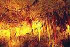 Sami
is near the village of Chaliotata and its magnificent Dragarati
Cave (open dawn-dusk, fee), which has
many orange and yellow stalactites and stalagmites. One of its hollows is so big and
the acoustics so good that opera singer Maria Callas preformed a concert
here and occasionally concerts are still held.
Sami
is near the village of Chaliotata and its magnificent Dragarati
Cave (open dawn-dusk, fee), which has
many orange and yellow stalactites and stalagmites. One of its hollows is so big and
the acoustics so good that opera singer Maria Callas preformed a concert
here and occasionally concerts are still held. 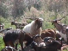 Aghia
Evfimia is a small coastal village with two hotels at the base of
Kefalonia's northern most appendage and where ferries to Ithika and
Stakes may be boarded. There are some decent pebble beaches off the
road from Sami heading into town. Above it, and spared by the quake,
is the traditional village of Drakopoulata. Close by are other
traditional villages clinging to the slopes of Mt. Agh. Dinati. The
soil has a particularly high mica content and causes the teeth of grazing
goats to turn silver in color.
Aghia
Evfimia is a small coastal village with two hotels at the base of
Kefalonia's northern most appendage and where ferries to Ithika and
Stakes may be boarded. There are some decent pebble beaches off the
road from Sami heading into town. Above it, and spared by the quake,
is the traditional village of Drakopoulata. Close by are other
traditional villages clinging to the slopes of Mt. Agh. Dinati. The
soil has a particularly high mica content and causes the teeth of grazing
goats to turn silver in color.  From Argostoli the road north towards
the island's tip reveals one beautiful scene after another. Aghia Kiriaki has the first good beach, below the village of Zola, and sits at
the elbow joint linking the Paliki peninsula to the rest of the island.
Eight km on, Myrtos Bay has a good pebble beach, a pricey cafe and sunbeds
but no afternoon shade. Its three km below the village of Divarata. Perhaps the best view of Myrtos for photographic purposes is along the road north to Fiskardo. From that high vantage point, you can admire the white sand, blue water and tall limestone cliffs of Myrtos.
From Argostoli the road north towards
the island's tip reveals one beautiful scene after another. Aghia Kiriaki has the first good beach, below the village of Zola, and sits at
the elbow joint linking the Paliki peninsula to the rest of the island.
Eight km on, Myrtos Bay has a good pebble beach, a pricey cafe and sunbeds
but no afternoon shade. Its three km below the village of Divarata. Perhaps the best view of Myrtos for photographic purposes is along the road north to Fiskardo. From that high vantage point, you can admire the white sand, blue water and tall limestone cliffs of Myrtos. 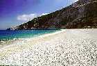 The next 760 years
found Kefalonia a victim of the machinations of the Normans, The Vatican
and the Venetians who were the most successful. Their Pirate-Robber-Count
Matteo Orsini founded a particularly heinous dynasty at the end
of the 13th Century.
The next 760 years
found Kefalonia a victim of the machinations of the Normans, The Vatican
and the Venetians who were the most successful. Their Pirate-Robber-Count
Matteo Orsini founded a particularly heinous dynasty at the end
of the 13th Century.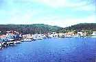 The nascent Greek
War for Independence brought Lord Byron to Kefalonia in 1823
as an agent for the London based Greek Committee. He subsequently went
to Messolonghi to lead troops against the Turk but was smitten by fever
and died. Greeks love Lord Byron and name many of their children 'Vyron'.
Even a whole neighborhood in Athens (Vyronas) is named after
after him.
The nascent Greek
War for Independence brought Lord Byron to Kefalonia in 1823
as an agent for the London based Greek Committee. He subsequently went
to Messolonghi to lead troops against the Turk but was smitten by fever
and died. Greeks love Lord Byron and name many of their children 'Vyron'.
Even a whole neighborhood in Athens (Vyronas) is named after
after him.
©2024 Real Estate in Greece.net | Advertise | Contact | | Bookmark Sitemap |

